Wetlands, Digital Elevation Models, and Stormwater Management
Authored by Bruce MacVicar and Thiruni Thirimanne (Department of Civil and Environmental Engineering, University of Waterloo) on December 13, 2022
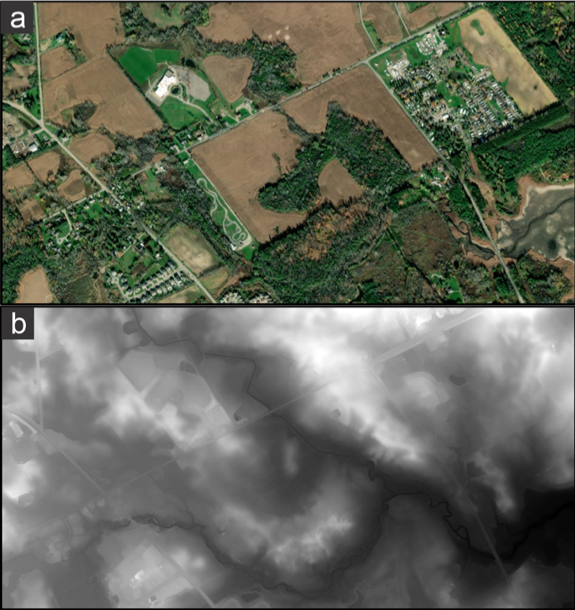
Thanks to technology, there are many ways of looking at the world. You may be used to seeing images like Figure a below, where thanks to satellites and other aircrafts taking thousands upon thousands of pictures and algorithms buried deep in programs like Google Maps, we can turn on ‘Satellite View’ and roam around the world by air, flying over city streets, following rivers, and climbing mountains. There is a lot we can see in these photos that we normally wouldn’t be able to, like how many swimming pools there are in a neighbourhood, sparkling blue behind the backyard fences, and whether or not patches of forest are connected to each other. In the figures below we can see a few roads and some farm fields. The large building towards the top left is a church surrounded by green sports fields. The top right shows a trailer camping park, and the lower right is a wetland with a creek draining into it, showing as a dark squiggling line sometimes visible through the trees.
As water resource engineers and researchers trying to think of better ways to manage the water that runs off from our cities, we spend a fair bit of our time looking at a type of map called a digital elevation model or DEM. DEMs break up the world into grids and assign average ground elevations to each grid square. An example is shown for the same area in Figure b. Elevations are represented on a scale from white to black where lower elevations are black and higher elevations are white. With this representation, we can see that the wetland at the lower right is at the lowest local elevation, and that there are two main tributaries coming into the wetland from the left and top of the frame, respectively. These DEM grids can have different resolutions, with some coarse DEMs made on a 100 m grid or larger, but our figure was made with a 50 cm grid, which means we can see a lot of detail. For example, you should be able to see the roads as lighter lines, which means they are higher than their surrounding landscape. You should also be able to see that the green fields surrounding the church in Figure a are grey and uniform, which means they are flat, likely because they were leveled as part of the field preparation. The dark line of the tributary on the bottom of the frame shows up as a squiggle, which is typical for a creek, but the tributary that goes to the top of the frame is a dark line with smoother gradual turns, likely because it was dredged and straightened to improve drainage. DEM’s thus capture an abundance of data that can be used in many spatial applications to calculate slopes, contour lines, drainage areas and flow directions. Modern technology means we can repeatedly fly drones or planes equipped with laser imaging, detection, and ranging or ‘lidar’ scanners to map the present topography and calculate the changes over time.
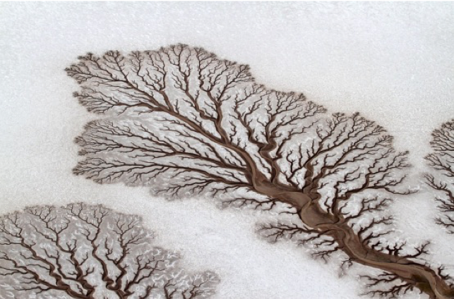
If we remove the influence of humans, the patterns we typically see in DEMs were caused by erosion from flowing water. To appreciate this, imagine a completely flat bed of sand in an outdoor sandbox with wood walls. Imagine now we cut an opening in the middle of one wall, making sure that the bottom of the opening is a little below the level of the sand, and then we wait. Rain falls on the sand, soaks in, and some water leaves through the opening we cut. If there is enough water and we watch carefully, we will see that the water carries a little bit of sand with it. This sand was moved or ‘eroded’ by the water, most likely from right beside the opening where we should now see a small dip in the sand level. If we leave our imaginary sandbox in the sun and rain for days and weeks, we will see more sand leaves and our little dip becomes a little rivulet. Water will flow in this rivulet when it rains, and more sand will move through it, transported from somewhere upstream. As time passes, our little rivulet will grow and split, reaching farther and farther up into the sandbox with a growing network of tendrils as the sand continues to be moved out of the sandbox. The rivulets and tendrils will look more like little rivers as they move around, eroding sand from the banks, depositing bars, and creating dunes and meanders. The little rivers will get wider and deeper so that the surrounding areas start to stand out as hills around our network. A beautiful photo of this process taken by Arianna Franco (2012) is shown below and online here. The lack of vegetation and the rarity of heavy rain in this area of Baja, Mexico meant that this network appeared after a single storm. In many places where we want to build cities, the slopes are subtle and vegetation relatively thick, so the process is much slower, occurring over centuries and millennia. Still, when we look at a high-resolution DEM, we can read this story etched on the landscape.
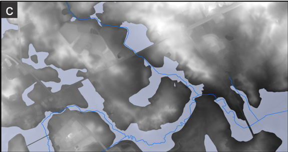
So, where do wetlands come in? Because they do present an anomaly of sorts. Wetlands, by definition, collect water, but the water doesn’t all run off. In some way, the water must be trapped so that it is not able to erode, to cut a channel and drain. We can find wetlands in different spots in our imaginary sandbox. The biggest might occur at the end, where the water flows into a pool and the sand being carried will drop to the bottom and collect, eventually building into a wet delta. The Nile River is a classic example of this type of wetland. Closer to home, the Don River used to flow into the Ashbridges Bay Marsh in an area separated from Lake Ontario by the sand that forms the Toronto Islands. People filled in the marsh to allow the development of the Port Lands, but because of flooding, the cost of constant dredging, and the need to clean up a hundred years of pollution, we are now rebuilding it at great expense, hoping to recover the flood protection and a fraction of the biodiversity that was lost. Wetlands also occur along the rivers, where the meandering of the channels and the formation of bars can create backwaters and little pockets cut off from the main flow. If we add mapped wet areas to our DEM (shown in Figure c below), we can see that many wetlands surround the tributary channels in low-lying areas called the floodplain. The floodplain will fill up during floods, slowing down the passage of the floods and dissipating their energy. Similar to natural deltas, they teem with plants and animals due to the abundant water and rich soil.
We can also find wetlands farther upstream in our sandbox or in our DEM, past the point where there is a clear river channel. These wetlands are not scattered randomly around the landscape but occur in the low areas and often connect downslope to other wet areas. A good example is shown in Figure c where there is a series of wetlands stretching up to the top left. The road network breaks up the continuity, but we can see that this lower lying area acts as a type of third tributary, collecting water and transporting it overland and underground to eventually join the river. If we look back to our photo in part a, we can see that many of these wet areas are also forests, likely because they are more difficult to farm and so were left untilled. In these smaller wetlands the water will collect, but there will likely be few storms where it is deep or powerful enough to overcome the strength of the roots of the plants that grow there and so carve out a clear river channel.
If there is one thing to know about water flow, it is that it moves much faster over the top of the ground than through it. For example, water can easily move one meter per second or 3.6 km per hour in a creek, but it will move only about one centimetre per hour through an average saturated sandy ground. This difference means that any time we pave or build on land so that it becomes impervious to water, rainfall will skip the phase where it moves slowly through the ground and go directly to the phase where it moves quickly through channels. The effect is like taking someone off a horse and putting them on a rocket ship. The acceleration of runoff is the big reason that urban development for houses, roads, stores and workplaces will generally lead to bigger floods. As the practice of stormwater management has developed, we have come to realize that all wetlands are important. The small inconspicuous wetlands we see in forested and rural landscapes are critical for slowing the water down to give it time to seep into the ground and get soaked up by plants. By the time the water gets to the channels, it’s really too late. If we get rid of all of the small wetlands, the volume of water sent down the channels will be much higher than would have occurred prior to the city building, which means poor water quality, increased erosion, and high flood risk.
Most developments now require that we build engineered wetlands to try to mimic natural analogs in an effort to capture their benefits. A good design, however - a smart design - will consider what is already there. How do the natural landforms interact with existing and new developments? How do the existing wetlands help us to reduce flooding? A wetland that develops naturally over thousands of years of rain and sun can tell us something about what works best in the place that we are. Yes, it takes some time to learn a landscape's story and to ensure we protect the most important pieces. But we have the tools to do it and are learning to do it faster and better. And what is the alternative? Should we continue to wipe out small wetlands before we can demonstrate how important they are? Should we spend more money to try and generate poor copies of them that cannot match their function and biodiversity? City building is a permanent change to the landscape, at least in our lifetimes. The choices we made in the past have brought us to a crisis point in terms of climate and biodiversity that should not be ignored. We’ve impoverished our world by speeding up runoff, knocking out those little bumps in the landscape where wetlands form as part of urban development. We need a different approach.